The TEMcompany product range
Light and portable
sTEM

The adaptable sTEM and sTEM profiler deliver accurate, reliable, efficient, and affordable geophysical surveys.
Conducting single-site measurements, capturing data beyond 500 m (1650 ft) depth. Affordable and robust, the modular sTEM family is operated via an Android or iOS app.
Built for – Adaptable system for groundwater mapping, MAR, and sand and gravel deposits.
Depth of investigation – Up to 600 m (2000 ft).
Dual moment – 1 Amp and 5 /10 /20 Amp.
Portable: Shipping boxes for easy travel.
Connectivity – Wi-fi, iOS & Android app.
Weight – Systems from 15 to 40 kg (33 – 88 lbs).
Towed system
tTEM
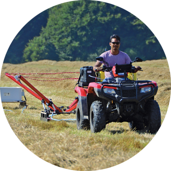
The tTEM, SnowTEM, and FloaTEM deliver large-scale area coverage for land and water-based geophysical mapping.
Towed by an ATV, quad bike, or dinghy, the tTEM family of geoscanners deliver high-resolution subsurface images for mapping groundwater, MAR, and sand and gravel deposits.
Built for – Large area groundwater mapping, MAR, and sand and gravel deposits.
Depth of investigation – Up to 180 m (600 ft).
Dual moment – 3 Amp and up to 30 Amp.
Drive speed: Up to 20 km/h (12 miles/h).
Connectivity – Wi-fi, iOS & Android app.
Weight – Systems start from 129 kg (284 lbs).
Mining and minerals
xTEM

With a compact setup, the xTEM enables discreet and non-invasive deep-penetration geophysical surveys.
Accurate and robust, the xTEM operates via an Android or iOS app. The transmitter capacity enables detailed measurements enabling 3-D imaging ideal for mining and mineral exploration.
Built for – Deep penetration, natural resource, mineral and mining target mapping.
Depth of investigation – Up to 600 m (2000 ft).
Dual moment low – high current – 1 Amp to 30 Amp.
Portable: Shipping boxes for easy travel.
Connectivity – Wi-fi, iOS & Android app.
Weight – Systems start from 20 kg (44 lbs).
New for 2025
TEM2Go

The TEM2GO delivers ultimate flexibility over the most challenging terrains: If you can walk it, the TEM2Go can gather the data.
Built for ultimate portability and flexibility on site, the TEM2Go delivers survey data for construction sites, groundwater mapping, and managed aquifer recharge.
Built for – Construction, groundwater mapping, MAR, and sand and gravel deposits.
Depth of investigation – Surface to 100 m (328 ft).
Dual moment low – high current – 1 Amp to 10 Amp.
Portable: Shipping boxes for easy travel.
Connectivity – Wi-fi, iOS & Android app.
Weight – Systems start from 35 kg (77 lbs).
Our TEM technology
The Transient Electromagnetic (TEM) geophysical survey method is a modern technique designed to measure vertical resistivity profiles with particular sensitivity to conductive materials.
- Non-invasive method using wire loops to transmit and receive signals
- Achieve depth measurements of up to 600 meters
- Particularly sensitive to conductive materials
- Leaves no trace on the survey site after data collection
- Highly efficient, requiring a transmitter loop and one or two smaller receiver coils
- Entire process takes only a few minutes, from setup to resistivity modeling

Where to use TEM
TEM surveys are highly versatile and are particularly effective in the following areas. Our instruments deliver accurate, fast data to solve many geophysical challenges.
Groundwater Exploration: Identifies freshwater reserves, saline water, and contamination zones to optimize well placement and drilling depth.
Mineral Detection: Locates mineral deposits based on their unique resistivity signatures.
Geological Mapping: Reveals the subsurface structure for various geological studies.
Environmental Surveys: Assesses contaminants and salination in the soil.

The benefits of TEM
Transient Electromagnetic (TEM) mapping is a non-invasive method that ensures that survey areas remain undisturbed, as it uses wire loops to transmit and receive electromagnetic signals without leaving physical marks on the terrain.
TEMcompany geoscanners enable fast, accurate geophysical data collection alongside easy instrument setup, delivering significant time savings for consultants, contractors, and clients.

Built to travel, engineered to explore
TEMcompany’s geophysical scanners are built to meet the requirements of geophysics professionals. Engineered for portability, our geoscanners are compact, easily transported in rugged cases, and ready for deployment by air or land, on water, in deserts, and frozen landscapes. Our product line, including the sTEM, tTEM, and xTEM, offers specialized instruments for precise subsurface imaging, ideal for applications ranging from groundwater mapping to contamination assessment and raw material exploration.
TEMcompany geoscanners and mobile apps enable survey teams to work faster and more accurately, delivering high-resolution data to significant depths.
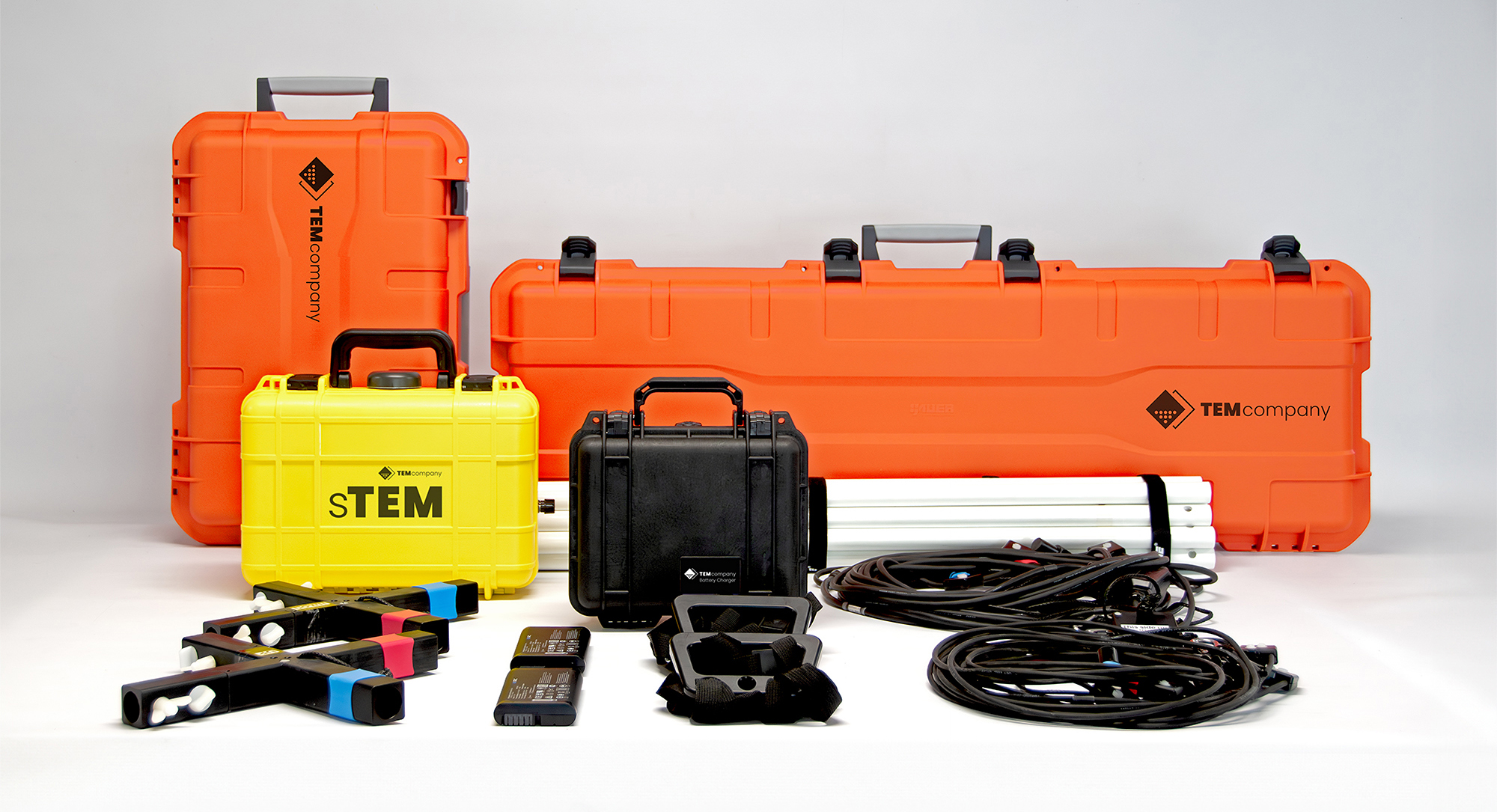
The sTEM integrated transmitter and receiver unit • Holds both transmitter (Tx) and receiver (Rx) electronics • Holds main PC for the real-time signal processing, data storage • Rugged ABS • Full-length hinge with two padlock loops • Two front latches secure transmitter contents • Pressure equalization valve for easy opening.
Travel case for the sTEM and battery case • Hardwearing polypropylene • Padded, fold-down ABS carrying handle • Full-length hinge, four padlock loops and four front latches • Pressure equalization valve for easy opening.
Battery charging case • Charges 2 x 14.4 V, RRC 2054-2 Li-Ion batteries • Watertight, crushproof, and dustproof case • Solid wall design, strong, light weight • Easy open double-throw latches • Automatic pressure equalization valve • O-ring seal.
Travel case for the sTEMprofiler coils, handles and rods • Hardwearing polypropylene • Padded, fold-down ABS carrying handle • Full-length hinge, four padlock loops, four front latches • Automatic pressure equalization valve.
sTEMprofiler rig rods • 4 pairs of rigid composite white rods for each frame (16 rods in total) • For Tx & Rx frames
Receiver coil (Rx coil)• Red and blue markers indicating the orientation of the coil.
Transmitter coil (Tx coil) • Red and blue markers indicating the orientation of the coil.
2 x carry handles for the sTEMprofiler rig • One rigid composite black handle for each frame.
Li-Ion batteries for the sTEM• 2 x 14.4 V, RRC 2054-2 • 2 – 4 hr continues operation time, dependant on configuration.
Cross brackets x 2 for the sTEMprofiler rig • 1 cross brace per frame with red and blue indicators for the coil positioning.
Field tested and trusted
What professionals say about our geophysical scanners.
Professionals worldwide rely on TEMcompany’s geophysical scanners for their reliability and accuracy in challenging environments. From mapping groundwater in arid regions to identifying subsurface layers beneath frozen terrains, customers choose TEMcompany’s instruments for their ease of use, portability, and robust performance. Whether used by NGOs, consultants, contractors, or researchers, TEMcompany’s instruments are recognized as an integral part of today’s complex subsurface exploration and environmental assessment landscape.